


Article included in
The innovative solution for surveying tasks with laser rangefinder. The integrated laser... more
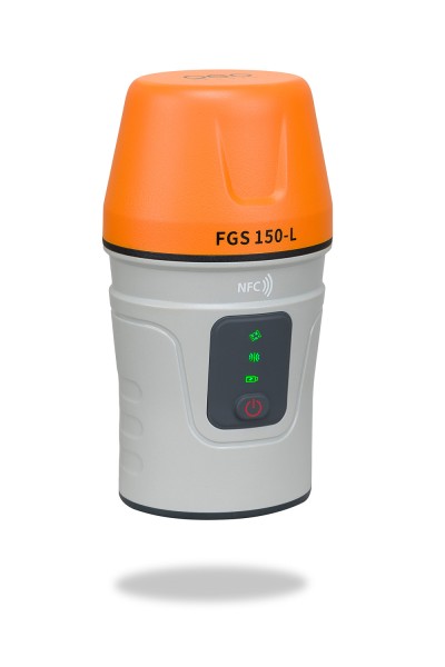
Product information "FGS 150-L"
The innovative solution for surveying tasks with laser rangefinder.
The integrated laser rangefinder, in combination with the 60° TILT compensator, allows the user to carry out surveying and marking work in inaccessible areas. The geo-FENNEL GNSS receiver FGS 150-L enables measurements from a distance of up to 10 m with an extremely high precision.
| Operating time: | 20 h |
| Bluetooth: | 5.0, Windows & Android |
| Accuracy static: | 2.5 mm + 0.5 ppm RMS horizontal, 5 mm + 0.5 ppm RMS vertikal |
| Accuracy SBAS: | 0.5 RMS horizontal, 0.8 RMS vertikal |
| Accuracy Stand-Alone: | 1.5 m 3D RMS |
| Power supply: | 5/9 V / 1,45 W |
| Extended size: | 80 x 70 x 150 mm |
| Weight: | 0,38 kg |
| Charging time: | 4 h |
| BEIDOU: | B1l, B2l, B3l,B1C, B2a, B2b |
| Storage temperature: | -30°C bis +60°C |
| Dust / water protection: | IP 67 |
| Operation temperature: | -20° C bis 50°C |
| GLONASS: | G1, G2, G3 |
| SBAS: | L1C/A |
| QZSS: | L1C/A, L2C, L5, L1C |
| GALILEO: | E1, E5a, E5b, E6c, E5 AltBOC |
| GPS: | L 1C/A, L1C, L2P, L2C, L5 |
| Channels: | 1590 |
| Accuracy DGPS: | < 0,4 m 3D RMS |
| Accuracy RTK: | 8,0 mm + 1 ppm horizontal, 15.0 mm + 1 ppm vertical |
| Protocol: | RTCM2.X, 3.X, CMR(GPSonly), CMR+(GPSonly) |
Related links to "FGS 150-L"
Properties: "FGS 150-L"
| Operating time: | 20 h |
| Bluetooth: | 5.0, Windows & Android |
| Accuracy static: | 2.5 mm + 0.5 ppm RMS horizontal, 5 mm + 0.5 ppm RMS vertikal |
| Accuracy SBAS: | 0.5 RMS horizontal, 0.8 RMS vertikal |
| Accuracy Stand-Alone: | 1.5 m 3D RMS |
| Power supply: | 5/9 V / 1,45 W |
| Extended size: | 80 x 70 x 150 mm |
| Weight: | 0,38 kg |
| Charging time: | 4 h |
| BEIDOU: | B1l, B2l, B3l,B1C, B2a, B2b |
| Storage temperature: | -30°C bis +60°C |
| Dust / water protection: | IP 67 |
| Operation temperature: | -20° C bis 50°C |
| GLONASS: | G1, G2, G3 |
| SBAS: | L1C/A |
| QZSS: | L1C/A, L2C, L5, L1C |
| GALILEO: | E1, E5a, E5b, E6c, E5 AltBOC |
| GPS: | L 1C/A, L1C, L2P, L2C, L5 |
| Channels: | 1590 |
| Accuracy DGPS: | < 0,4 m 3D RMS |
| Accuracy RTK: | 8,0 mm + 1 ppm horizontal, 15.0 mm + 1 ppm vertical |
| Protocol: | RTCM2.X, 3.X, CMR(GPSonly), CMR+(GPSonly) |
Supplied with: 1 x GNSS antenna FGS 1 1 x geo-FENNEL Survey Software... mehr
Supplied with:
|
|
|
|
|
|
|
|
More about the product
If you need more information about the article, you will probably find it here:
Sales contact/en/contact
Downloads
Viewed